The hikes in Point Reyes National Seashore have some of the most stunning scenery on the Californian coast and these are 10 of the best hiking trails to do there.
Having said that there are plenty of other options for hiking in Point Reyes but this is just an overview of some of the best ones. Note that some of the hikes in Point Reyes are not that long but you can combine a few together to make a long day out on the trail.
At the end of the article, I have included a link to a post I did about the best places to visit in San Francisco during my time there.
“Take only pictures; leave only footprints.” That’s the number one rule of Point Reyes National Seashore. You can’t take anything out of the area with you, and that includes seashells. It’s a protected area and it’s a good rule.
Side note: Being along the coast near San Francisco it’s best to check the weather before going as you could have a lovely sunny day with great views or end up with foggy conditions and hardly any view.
Also, be aware that there can be bad outbreaks of wildfires in the area so check the news before going as well.
Hikes In Point Reyes
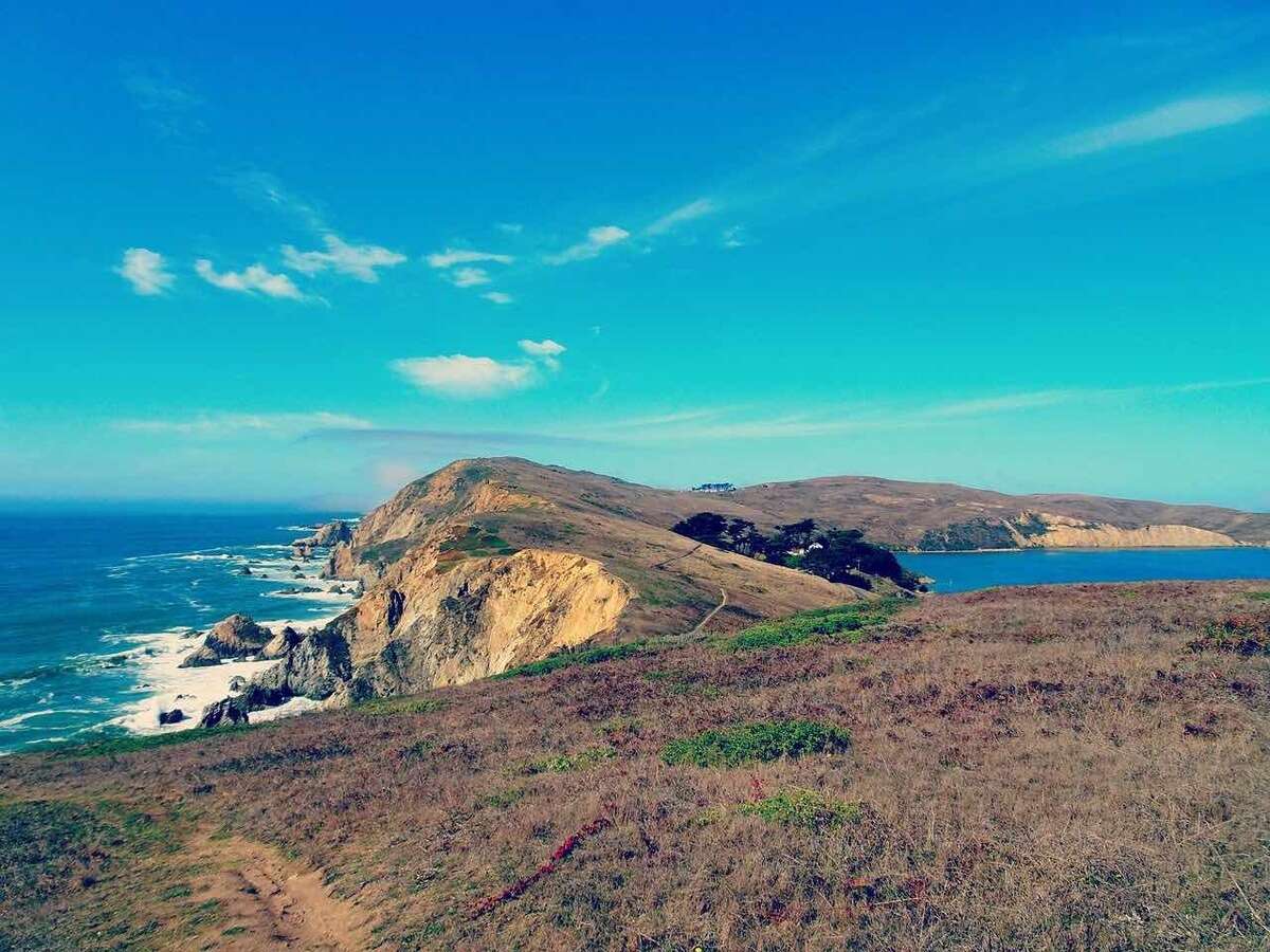
Tomales Point Trail

The Tomales Point Trail is, out of all the hikes in Point Reyes, the best one you can do.
The stunning cliff scenery is some of the most iconic of the Californian coastline and the area is a little quieter in general than some other hikes here, getting you closer to some peace in nature.
Depending on how far you walk on the trail it can take anywhere between 1-5 hours to complete.
There’s also plenty of elk when out hiking at Tomales Point so keep an eye out.

Chimney Rock Trail
The Chimney Rock Trail is a reasonably short hike to do but is also one of the most popular hikes in Point Reyes and an easier one. It only takes around 30 minutes each way to do it.
There is an old lifeboat station on this walk to see and you may get glimpses of elephant seals.
When in that part of Point Reyes head over to the Point Reyes Lighthouse after the walk.
Coast Trail to Bass Lake

The Coast Trail will take you to stunning views across the beach and down to Bass Lake. It’s a 6-mile trail so is an easy day out for hiking in Point Reyes and will take roughly 3 hours to complete.
It’s a reasonably popular trail but for good reason as, apart from the hiking, it’s known for its birdwatching.
Point Reyes Beach

Although this is technically not an actual trail hike, the Point Reyes beach is stunning and very long at 11 miles and is known as “The Great Beach.”
It’s great to walk along and you can start walking along it from either Abbotts Lagoon way or from the Point Reyes Lighthouse direction.
You can turn off the beach at either Point Reyes Beach South turnoff or Point Reyes Beach North turnoff if you don’t want to walk the whole beach.
The beach is dog-friendly if you want to walk with your dogs(s).
Note: Walk the beach at low tide for great expanses of sand.
This is definitely one of the ‘best hikes in Point Reyes.’
Hike to Alamere Falls

Almere Falls is a stunning waterfall that cascades down onto the beach. The way to get there is by following the Palomarin Trail (see below). The hike to the waterfall takes you through the forest and also has excellent coastal views.
Important: You must time this hike so that when you reach the falls it is low tide.
It takes around 1 and a half hours to drive from San Franciso to the trail.
Palomarin Trailhead

The Palomarin Trailhead to Wildcat Beach, via the Alamere Falls, is a great longer hike in Point Reyes to do with beautiful forest scenery and the epic Alamere Falls along the way.
This is one of the most popular of all the hikes in Point Reyes so don’t expect the place to yourself.
It’s around a 13 miles hike roundtrip.
Fact: There are only 2 tidefalls in California and Alamere Falls is one of them.
Bear Valley Trail
The Bear Valley Trail is by Point Reyes Station and will take you through lush forest
The great thing about this trail is that you can visit the Alamere Falls and camp at the Wildcat Camp and you have the option to join up with other trails, like the Coast Trail, that will take you down for epic coastal views.
It takes around 4 hours to hike it and is a good trail for campsites to camp overnight (see further down the post for camping in Point Reyes options).
Abbotts Lagoon Trail
The Abbotts Lagoon Trail takes you to, just that, a lagoon called Abbotts, and it’s one of the easiest hikes in Point Reyes.
You get several different sceneries on this trail, from marsh to meadows.
This is a prime destination for birdwatching and can get busy for that and also runners love it as well.
Estero Trail to Drakes Head
The Estero Trail is a 9-mile hike that takes you across open terrain with excellent views over Drakes Estero and Drakes Bay. At the start of Estero Trailhead, you will pass through a forest for a while that has many birds to see.
Note: The Drakes Estero area is closed from March 1 until June 30 to protect seals and no pets are allowed at any time of the year.
Point Reyes Lighthouse

The walk down to Point Reyes lighthouse is not such a long one so I’ve put it at the end here. It’s a good place to take a look at and a historic place.
You can add it to other trails mentioned here, for example, after doing the Chimney Rock Trail you can walk there within an hour.
Note: The lighthouse is only open at the weekends to take a walk down to it on lots of stairs!
Camping in Point Reyes
There are numerous campsites in Point Reyes so if you want to spend the night there in nature rather than just going for a day trip then it’s possible.
There are 12 campsites for your hikes in Point Reyes that accommodate 1-6 persons and 12 sites that accommodate 7-25 persons.
You can make a reservation for a campsite at the official Point Reyes website (click that link).
There is also the Point Reyes Hostel which is by the park where you can stay in.
Hiking In Point Reyes

Hiking in Point Reyes National Seashore is a must-visit for coastal scenery if you are in San Francisco and have the time to go there.
There’s the Bear Valley Visitors Centre near the beginning of the park which is worth popping into to get more information on the area and to take a look at some of the history. You can also pick up maps of the trails there.
Try and take a look at the Point Reyes Shipwreck which is great for photography and is located by the city of Inverness in the area.
Check the current conditions (link to the official website of the National Park Service)of the trails before doing any hikes in Point Reyes.
If you had only one trail to do then I would recommend the Tomales Point Trail, or if you’re very short on time then do the Chimney Rock Trail.
For more of California take a look at the best places to visit in San Francisco.
I recommend using SafetyWing Travel Insurance for your trip, just in case, it’s best to be prepared.
Share the hikes in Point Reyes, California:


")