The Routeburn Track is an excellent 33km 2-3 days hike into the mountains and deep mossy forests of New Zealand’s south island. This is what to expect and how to do it.
It’s only a 45-minute drive from Queenstown to the start of the hike which is also a stunning drive passing along a lake.
The Routeburn Track Hike
The Routeburn Track is located in the Fiordland National Park, which is one of the most stunning locations for hiking in New Zealand. Or should I say “tramping” as that’s what the New Zealanders’ refer to as hiking.
This is an account of what the Routeburn Track is like to hike (although naturally weather conditions will most likely be different), along with practical advice at the end on how to go hiking the Routeburn Track yourself.
I hiked on many trails in New Zealand during my several weeks there and the Routeburn Track is one of my favourites.
The beginning of the hike starts with a relaxed 1-2 hour walk through a beech forest with streams, waterfalls, and a fast-flowing river running through it all, to reach the first campsite for the night at Routeburn Flats.
Raining slightly when there (being New Zealand there’s a high chance it will for you as well) just adds to the forest atmosphere providing a misty scene amongst the mossy interior.
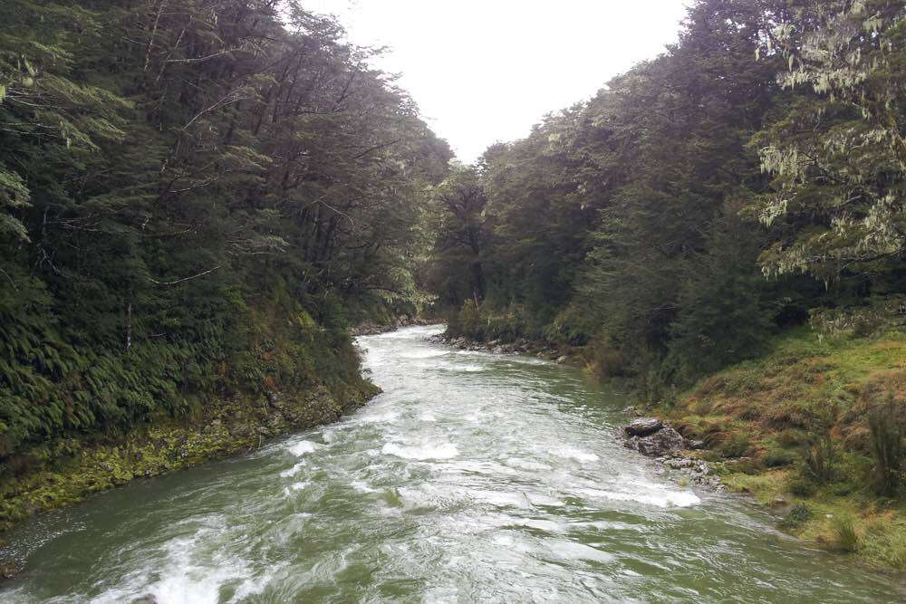
With the fresh water falling down from the mountain tops there is no need to purify water, just drink some of the freshest water you could have straight from the streams.

Waterfalls cascade down the sides of the mountains and a stream runs through the low ground as you reach the campsite.

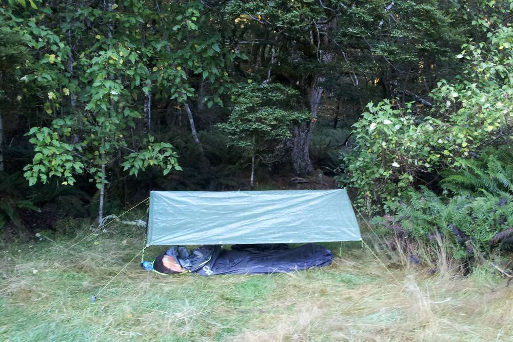
Reaching the campsite for the night I set up my bivy bag and took in the view while having dinner.
This is a good place for camping. There is a hut you could stay in but it is much better to camp out and get closer to nature.

Waking to a beautiful blue sky you can warm up in the sun and then start the walk uphill to reach the mountain top.
This hike upwards takes about 2-4 hours depending on how slow you want to go, and as you go higher up you pass through the tree line and into alpine scenery.

There is a small alpine lake on the way up to see called Harris Lake and that takes you up to the Harris Saddle.


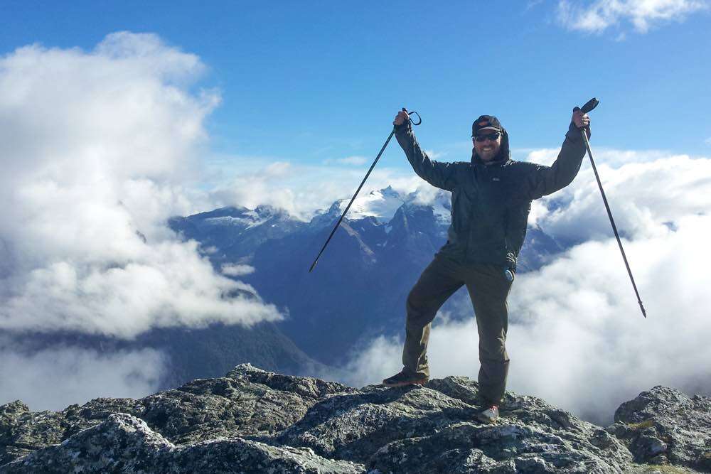
Reaching the pass at the top called Harris Saddle you get a view across to snow-peaked mountains all around, such as the Crosscut and Sabre. The Harris Saddle can be done as a long day hike if you don’t want to hike all of the Routeburn Track.

Climbing up the side excursion trail to Conical Hill is worth the while for even better views.
Climbing the Conical Hill in autumn (when I was there) can be a little tricky, as a lot of the rocks you have to scramble up are covered in slippery ice. However, it’s worth it.

It takes again around 2-4 hours to reach the campsite for the 2nd night. This is an easy walk traversing around the mountain while descending.
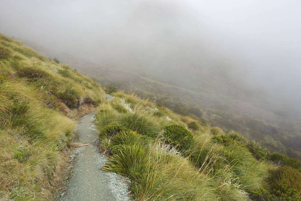
The clouds can come and cover the area in a foggy mist, making it impossible to see anything, but adding a great surreal feeling to the mountain.
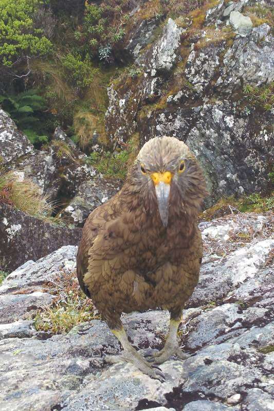
You may be lucky enough to have the company of the Kea.
Kea is the only alpine parrot in the world and they are very curious and social birds. It’s easy for them to get close to you, but be careful, as they like to peck at your belongings.
Watching and listening to the Kea flying in and out of the misty clouds is very cool.

The clouds disappeared slightly and I saw a lake below with sheer rock cliffs rising up behind it surrounded by a forest.

Then you descend down from the mountain to reach the next campsite at Lake Mackenzie Hut. This is where one of the most unexpected joys of the walk comes in.

On the descent, you enter a deep mossy forest and it feels like you have entered The Lord of the Rings movie (filmed in New Zealand). It is a magical world all of its own. Truly brilliant and surprising.


Having reached the campsite you can go and chill down by the lake. Apart from the scenery, the Mackenzie Hut campsite is pretty bad, cramping all the camp spots close to each other.

The next day it is around 4-6 hours walking to get to the exit of the track at a place called The Divide.
This part of the walk is all in a forest, with a few brief moments in the clear to see the views of the mountains around.


It is on this part of the Routeburn Track hike that you can see some of the more impressive waterfalls, cascading down the sides of the cliffs.


Some of the smaller waterfalls make for great stops to drink some of the mountain water.
It’s the larger waterfalls that send spray flying across the Routeburn Track. Sometimes during heavy rains, you will have to take detour trails due to flooding from them.
You eventually descend from the mountain and forest and back to the road.
Hiking The Routeburn Track Practical Advice
New Zealand is famous for its great walks, and getting out hiking (or tramping as they call it in New Zealand), is one of the best ways to see nature.
You can get to the Routeburn Track either from the Queenstown side or the Te Anau side. It is possible to walk the trail in either direction. This account was walked from Queenstown side, by Glenorchy.
You can officially camp at three campsites on the trail and the three huts.
Staying in the huts during peak seasons will cost you around 50 New Zealand dollars a night, and campsites will be around 15 dollars a night.
In the off-season which starts on the 1st of May, the prices drop dramatically to 15 dollars a night for the huts and 5 dollars for the campsites.
Officially you are not allowed to freedom camp (camp for free) on the trail, but there are one or two possible places where this could be done, although I did not do this.
Personally, I believe taking your own camping gear and sleeping out is better than staying in the huts. Either way, if you make it to New Zealand’s South Island then definitely consider hiking the Routeburn Track. In fact, don’t consider it, just go!
Have a read of this post about hiking the Kepler Track which is also in the region near Te Anau and the Routeburn Track. The Kepler Track was also one of my favourite hiking routes in New Zealand.
I recommend using SafetyWing Travel Insurance for your trip, just in case, it’s best to be prepared.
Share the Routeburn Track hike:


")

")
")
Nice write up on the track! Bill and I send our best wishes for your future travels! (We’re the texans you met on the trail)
Hahaha. Hey guys! Cheers. Send me a email through the contact from with your Facebook or whatever details so we can keep in touch 🙂
I really wish I’d had more time to hike in New Zealand, this sounds like a great adventure. Some of your photos are incredible and I love that you managed to catch a Kea. They are such strange birds!
Thanks Katie! Yeah I love the walks in New Zealand. Those Kea are great 🙂
Great post, thanks!
Now, just out of curiosity, and supposing that one can’t find a place to stay in either Lake Mackenzie or Routeburn Falls Huts (but did manage to book places in Lake Howden Huts and Routeburn Flat Huts), where would those free camp places you mention be? 😉
As far as I remember camping near the falls hut would be hard, I camped on the flats and hiked to the lake in one day from there not staying around the falls, it’s not that hard. Around the lake there are plenty of places, just don’t go anywhere near the rangers and official campsite, head to the other side of the lake.
Hi. How can i pay for the campsite? Do i need to pay everytime i reached the campsite or pay before start the hiking? also do i need to have any permits to do this walk? Thanks
Hey,
You pay for the campsite in advance either online or at the local parks office called DOC in a nearby town/city. You have to pay online and not just show up as they have a certain number of people allowed in at one time. However I did some freedom camping on other hikes where I didn’t pay and just camped rough in the woods, but nowhere near the campsite.
This is the official website for booking campsites: https://booking.doc.govt.nz/
Enjoy your hike 🙂
Hello what kind of food did you pack for the the three days?
Pingback: 10 Of The Best Hikes In The World (You Can Do) - Backpackingman
Pingback: The Most Amazing Hikes on New Zealand's South Island
Pingback: Things to Do in Queenstown - The Trusted Traveller
Instant noodles, nuts and raisins, and a large sandwich for the first day!